Thursday, January 20, 2011

How-to use LandMapper and consumer-grade GPS data-logger to quickly map salinity on farm fields

Task on hand – estimate salinity level on fields planned for rice next year. Six fields with total area of 322 acres were selected by farmer. Equipment on hand: two LandMappers with different size probes attached (measuring electrical conductivity (EC) down to ~ 8” and 18”), Columbus GPS data-logger, all-road vehicle or “Mule”. Three people – farmer driving a '”mule” image and recording data on paper, one person measuring with Landmapper at 18” depth, other person measuring EC with LandMapper to 8” depth and recording POI or way points with GPS.
Results: 30 points recorded in less than 1.5 hour (including about 45 min break to wait out the rain). EC in the field varied from 5 mS/m to 106 mS/m on surface; and from 19 mS/m to 400 mS/m in deeper layer.
Problems encountered – pouring rain, all electronics got wet, one LandMapper refused to store data (so it is always a good idea to write measurements on paper as a backup :), we did small repair of probe banana-plug contact with pocket knife.
To see what type of soils are on the farm and where we measured EC, download and install Google Earth from http://earth.google.com/ . Then go to Google Earth Interface
and download soilweb.kmz plugin. Save it to your harddrive. imageIn Google Earth program go to File/Open and open attached .kml and KMZ files. You will see locations of our measurements, satellite imagery of the fields and outlines of soil map units. Clicking on yellow abbreviations bring quick reference about soil series name and profile. Clicking on soil name brings you a lot of detail information about soil properties, scientific soil name, typical native plant (with hyperlinks to plant database) and recommended soil usage.  This database is maintained by UC Davis.image

Monday, January 17, 2011

Geotomo Software - Downloads and prices for 2011

Landviser offer the same pricing for geophysical interpretation and imaging software as Geotomo, Inc.
You can download the most current versions of software from here:
Geotomo Software - Downloads:
View current pricing for software current pricing for GeoTOMO software and Landviser's Equipment.
Landviser, LLC is authorized distributor of RES2DINV/RES3DINV software and preferred vendor for customers in North and South Americas (registered in CCR system), Africa, Russia, China. Please contact Landviser, LLC before contacting other dealers or Geotomo directly as we will meet or beat quotes by other dealers. We accept purchase orders from US customers as well as VISA/MC and wire transfers to our US bank account and ship worldwide.
To get official quote, contact Landviser, LLC at info@landviser.com or +1-609-412-0555.

Wednesday, November 10, 2010

Daymet historical 1980-2003 Daily weather data for US

A real gem - historical 1980-2003 DAILY weather data for US - extrapolated on 1 sq km grid. Available as summary maps or RAW!
Daymet Home Page:
You can download the raw data for any place in US and use it in research - probability, crop modeling, etc.

DAYMET U.S. Data Center - A source for Daily Surface Weather Data and Climatological Summaries
Daymet is a model that generates daily surfaces of temperature, precipitation, humidity, and radiation over large regions of complex terrain. Daymet was developed at the University of Montana, Numerical Terradynamic Simulation Group (NTSG), to fulfill the need for fine resolution, daily meteorological and climatological data necessary for plant growth model inputs
Using a digital elevation model and daily observations of minimum and maximum temperatures and precipitation from ground-based meteorological stations, an 18 year daily data set (1980 - 1997) of temperature, precipication, humidity and radiation has been produced as a continuous surface at a 1 km resolution. A wide range of summary and point daily data over the conterminous United States are now available.
No other data at this temporal and spatial resolution exists. This data is currently being distributed, free of charge, from the NTSG lab through its outreach component, the EOS Training Center Natural Resource Project.
The Daymet U.S. database is indexed by the Oak Ridge National Laboratory, Distributed Active Archive Center (ORNL DAAC), in their list of Regional and Global Data for Global Change Research

Monday, October 25, 2010

USDA Provides Disaster Assistance to Producers of Rice, Upland Cotton, Soybeans and Sweet Potatoes in 2009

USDA Provides Disaster Assistance to Producers of Rice, Upland Cotton, Soybeans and Sweet Potatoes
Fri, 22 Oct 2010 13:20:36 -0500
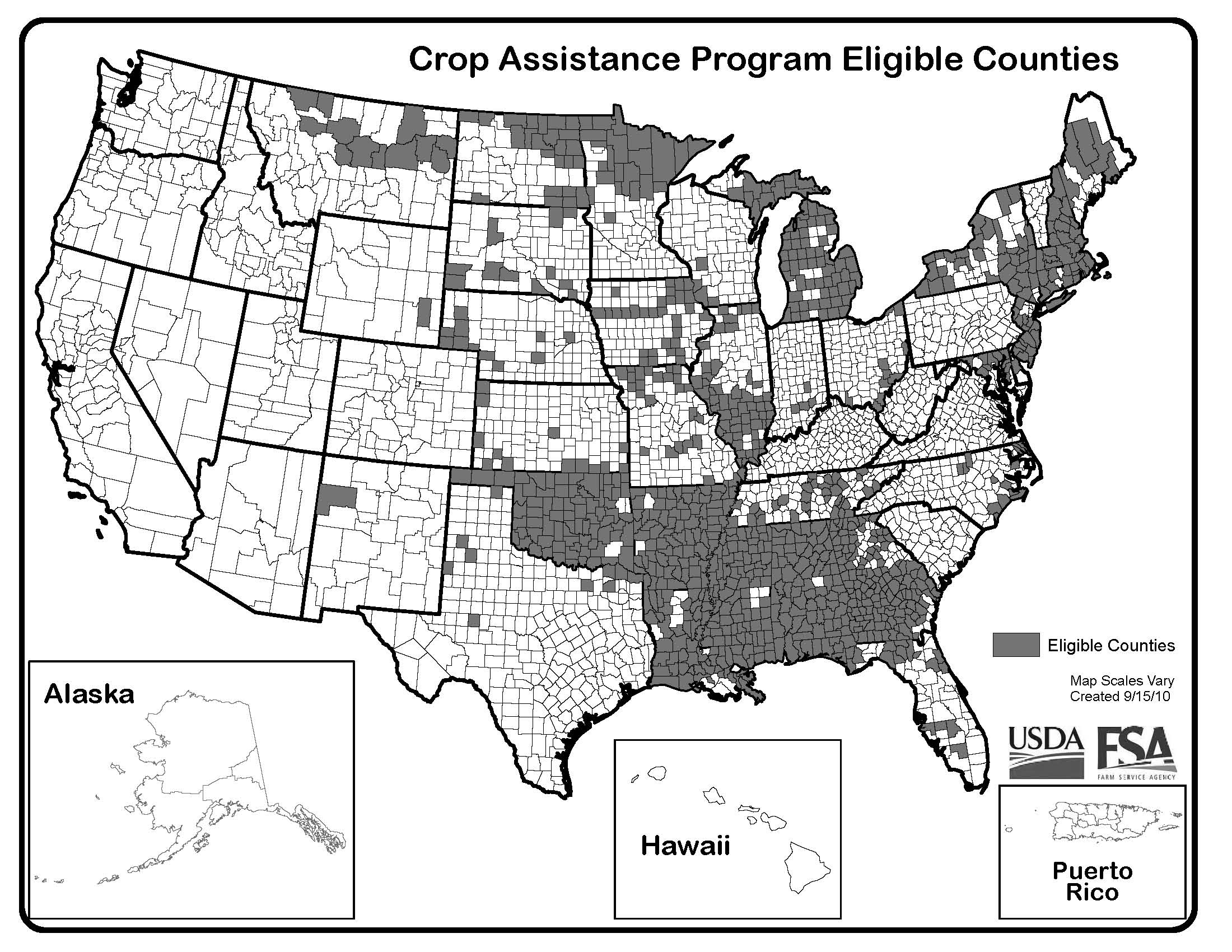
Note that this program covers losses occurred in 2009 crop. So far it looks like 2010 rice harvest was worse than 2009, lending  to excessive heat and luck of moisture, however 2009 brought excessive rainfall and flooding in Mid-South, thus this assistance program for 2009 crop loss was just approved on October, 22, 2010. Only few counties are covered in TX, but non of rice-growing counties. However, all AR and major part of LA and MS counties are covered, see map below.  A list of eligible disaster counties for CAP is located  here (click to download XLS file).
WASHINGTON, Oct. 22, 2010 - Agriculture Secretary Tom Vilsack announced that starting today up to $550 million in disaster assistance will be issued to producers of rice, upland cotton, soybeans and sweet potatoes that suffered losses because of excessive moisture or related conditions in 2009. This assistance will be issued by the Farm Service Agency (FSA) through the Crop Assistance Program (CAP).
"Producers of these crops suffered quality and quantity losses caused by excess moisture in 2009," Vilsack said. "They continue to feel the effects of those crop losses and this program will provide timely assistance."
Payments will be made available to producers of eligible crops that received Secretarial disaster designations due to excessive moisture or related conditions in 2009.Producers of eligible crops on farms in disaster counties who certify to a 5 percent or greater crop loss in 2009 due to excessive moisture or related conditions will receive a payment based on a predetermined payment rate times the planted acres of the crop. Per acre payment rates will be prorated by FSA in order to keep payments within available funds for the program. Producers will initially receive 75 percent or their CAP payment and once sign up is complete they will receive up to an additional 25 percent. The predetermined payment rates for the eligible crops are:
Long grain rice – $31.93 per acre; Medium or short grain rice – $52.46 per acre; Upland Cotton – $17.70 per acre; Soybeans – $15.62 per acre; Sweet potatoes – $155.41 per acre. The general eligibility provisions, payment limits and adjusted gross income limits that apply to FSA programs apply to CAP. No person or legal entity (excluding a joint venture or general partnership), may receive, directly or indirectly, more than $100,000 in CAP benefits. Additionally, CAP payments will be treated as 2009 revenue under the Supplemental Revenue Assistance Payments (SURE) Program.
CAP is funded through Section 32 of the Agricultural Adjustment Act of Aug. 24, 1935, which allows the Secretary to use funds to reestablish the purchasing power of farmers, ranchers and producers. For additional background on CAP, visit http://disaster.fsa.usda.gov.
For more information about USDA Farm Service Agency disaster assistance programs, visit a local FSA county office or http://disaster.fsa.usda.gov.
USDA is an equal opportunity provider, employer and lender. To file a complaint of discrimination, write to USDA, Assistant Secretary for Civil Rights, Office of the Assistant Secretary for Civil Rights, 1400 Independence Avenue, S.W., Stop 9410, Washington, DC 20250-9410, or call toll-free at (866) 632-9992 (English) or (800) 877-8339 (TDD) or (866) 377-8642 (English Federal-relay) or (800) 845-6136 (Spanish Federal-relay). USDA is an equal opportunity provider and employer.

Monday, May 17, 2010

Samsung HZ35W compact ultra-zoom digital camera with GPS

I just got this camera for my impeding trip to Kenya and testing it. So far camera functions are superb, with 15x optical zoom and wide-angle lens, it is compact and takes great pictures on auto, but also have full manual control. What it lacks is printed manual and other detail instructions. The other BIG problem is GPS base maps. You will need to download them from www.samsungimaging.com, not samsung.com as stated in PDF manual. And, search for model WB650, not HZ35W. After jumping through the hoops I found this semi-direct link http://www.samsungimaging.com/learn/digital-camera-camcorder/productDetailView.do?forward=feature&prdCtgSeq=7&langPrdSeq=6037
You will need to agree to the terms, than enter serial code of your camera (on the bottom, HZ35W code will work) and check if code is valid. Than it will take you to download page. Manual for GPS basemaps is not download-able, no saveable and in scroll-down frame, after taking multiple screenshots, I was able to save it.
Now about the maps. Samsung states that 63 countries are covered, but You only have 3 attempts to download regional (country?) maps. Since others stated that getting 550 Mb map of US was a pain, I downloaded basemaps for whole world (required, ~100 mB) first, and then got Kenya, UK (for my possible venture into London during plane switch) and Russia/Ukraine. I was really surprised that those countries are available.:) Well, I just started US download, I got it in about 15 min, not bad. also I am not sure how detail those maps will be, but they are there!
After jumping through hoops, here is video how to, which is only available if you already went through all sites, entered serial number, etc. It teaches you how to do just that.:)
http://www.samsungimaging.com/learn/digital-camera-camcorder/goInstallGuideMovie.do
Pros:
1. Camera is pretty easy to use. Point and shoot and gets good pictures. Great wide angle + 15X optical! zoom.


2. Intelli-Studio for image editing is also straightforward. Camera connected fast with Win XP Pro PC, you don't even need to install Studio, it runs from camera. Camera is charging while uploads pictures.Short USB cable is actually a plus. It is proprietary by Samsung, so I have to be careful not to lose it. Old images are not removed from SD by default, but can be cleaned with a few clicks. I also installed the Studio to PC to download images into my Win Live folder which will automatically syncs between work and home PC. So I can work on images anytime from any comp. I am getting ready for netbook :) and planning to carry one with me on ventures around town/business travel. I am aware that netbooks do not have optical drive, so auto-install of software from camera instead of DVD is actually a plus! The software displays all info about each shot, including GPS coordinates, I am planning to use it in learning digital photography and may be for documenting my soil consulting trips and EC measurements.

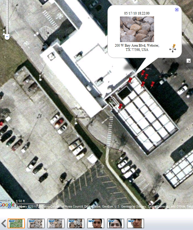
3. GPS actually fixed pretty quickly, about 2 min max (for the first out of the box fix, not bad!) when I was sitting outside waiting for car oil change, and it was not clear view of skies, I was on the side of the hole in concrete awning, sort of an atrium. Even without base maps, it displays pretty accurate location of the picture (through Intelli-Studio, it even shows address of Car Spa I was sitting at). Accuracy spread was also OK for not dedicated GPS, considering I was siting not in the crear sky view. The popped out picture of the stones actually shown exactly where I was sitting, other pins are close by (I did not move while taking all 7 pictures), but this spread to be expected even on hight end GPS.

Cons:
1.No hard copy user manual is included. Manual is on CD (and that is only thing which is on that CD, pretty wasteful, as all base maps on web, and manual as well, why include CD?). Although I like PDFs and generally prefer having a softcopy on computer for referral, sometimes it is nice to being able to play with camera outside and refer to book manual. I should go through additional loops to convert PDF to use on Kindle or Win Mobile Phone. Or netbook?:)
2. Basemap download and install is not easily available, see above. Although I found it and downloaded relatively painlessly, I am still working on getting basemaps on camera SD, this will be separate post. Also space limits - I will have to fill about 1 Gb with base maps...

Conclusions: I really like this camera and can envision having it with me at all the times. I am not a good photographer, but like to learn. Also I follow the motto "the best camera is the one you have with you". We got DSLR Pentax for Christmas, but it is too heavy and complicated to my taste, so my husband took it over, he likes to play with images and spends hours on editing. Now he shoots in RAW mostly, now there is always at least a week lag before he can post pictures. I don't like this. So this little Samsung will be My Camera.:)

Wednesday, May 12, 2010

Low-cost GPS logger

I had tested a small gadget called GPS logger from Columbus Visiontac.
Complete product name-description is:

Columbus V-900 Bluetooth GPS Data Logger (microSD , Voice Tag for POI, Driverless, Push to Log, 25 millions waypoints*, XP / Vista/ Linux / Mac OSX Compatible)

I tested it on some trips about a year ago. It is out of stock on most websites now, I don't know whats going on, but I have it and it is a cool little device both for fun and for field research. The cool feature is if you carry your digital camera and set up time in it to minute upon return to office you can link those pictures with Lat/Long and post on Google Earth for other to review. Or you can collect voice notes or waypoints and then load them to your PC and merge with other measurements. If you have it in your car all the time, it trucks your routs and date-stamp them so you can review notes and places you've been and merge that with soil maps, satellite imagery, etc. Indispensable for mobile Ag Consultant! I even tried to log EC data from Landmapper to merge with locations. It has worked a year ago, but now dis-organized as I am, I lost manual and software which came with it for PC communication. It still works and I have a whole bunch of data on it from recent trip to Winnie, TX - I was there mapping soil salinity on rice fields, but I cannot get it out!:( I will continue searching internet and my house, but may be someone can help with this??? Ok, that was pretty easy. Here is manufacturer website for downloads.Current versions are
Columbus V-900 User Manual V1.2 English Version updated 08-11-10 1.29M
Time Album V1.8 English Version
Updated: 10-03-31  1132K

 I will try to set up my new laptop with this and get those data out!
Setup instruction:
  1. Download and install Java (free, click here to download). It will ask you to verify your version of Java.
  2. Download and unzip the Time Album application (see link above).
  3. Launch the TimeAlbum application by double clicking on the unzip file above.

Tuesday, May 11, 2010

Solid Earth Geophysics Encyclopedia

Landmapper will be featured in 2nd edition of Solid Earth Geophysics Encyclopedia as the best small scale portable and accurate electrical resistivity/conductivity meter. Click here to read a draft of the article in 2nd edition of Encyclopedia.

1st edition Encyclopedia of Solid Earth Geophysics can be found here.
James, D.E. (Ed.)
Version: eReference (online access)
1990, 1344 p. eReference.
ISBN: 978-0-387-30752-7