Wednesday, November 10, 2010

Daymet historical 1980-2003 Daily weather data for US

A real gem - historical 1980-2003 DAILY weather data for US - extrapolated on 1 sq km grid. Available as summary maps or RAW!
Daymet Home Page:
You can download the raw data for any place in US and use it in research - probability, crop modeling, etc.

DAYMET U.S. Data Center - A source for Daily Surface Weather Data and Climatological Summaries
Daymet is a model that generates daily surfaces of temperature, precipitation, humidity, and radiation over large regions of complex terrain. Daymet was developed at the University of Montana, Numerical Terradynamic Simulation Group (NTSG), to fulfill the need for fine resolution, daily meteorological and climatological data necessary for plant growth model inputs
Using a digital elevation model and daily observations of minimum and maximum temperatures and precipitation from ground-based meteorological stations, an 18 year daily data set (1980 - 1997) of temperature, precipication, humidity and radiation has been produced as a continuous surface at a 1 km resolution. A wide range of summary and point daily data over the conterminous United States are now available.
No other data at this temporal and spatial resolution exists. This data is currently being distributed, free of charge, from the NTSG lab through its outreach component, the EOS Training Center Natural Resource Project.
The Daymet U.S. database is indexed by the Oak Ridge National Laboratory, Distributed Active Archive Center (ORNL DAAC), in their list of Regional and Global Data for Global Change Research

Monday, October 25, 2010

USDA Provides Disaster Assistance to Producers of Rice, Upland Cotton, Soybeans and Sweet Potatoes in 2009

USDA Provides Disaster Assistance to Producers of Rice, Upland Cotton, Soybeans and Sweet Potatoes
Fri, 22 Oct 2010 13:20:36 -0500
Note that this program covers losses occurred in 2009 crop. So far it looks like 2010 rice harvest was worse than 2009, lending  to excessive heat and luck of moisture, however 2009 brought excessive rainfall and flooding in Mid-South, thus this assistance program for 2009 crop loss was just approved on October, 22, 2010. Only few counties are covered in TX, but non of rice-growing counties. However, all AR and major part of LA and MS counties are covered, see map below.  A list of eligible disaster counties for CAP is located  here (click to download XLS file).
WASHINGTON, Oct. 22, 2010 - Agriculture Secretary Tom Vilsack announced that starting today up to $550 million in disaster assistance will be issued to producers of rice, upland cotton, soybeans and sweet potatoes that suffered losses because of excessive moisture or related conditions in 2009. This assistance will be issued by the Farm Service Agency (FSA) through the Crop Assistance Program (CAP).
"Producers of these crops suffered quality and quantity losses caused by excess moisture in 2009," Vilsack said. "They continue to feel the effects of those crop losses and this program will provide timely assistance."
Payments will be made available to producers of eligible crops that received Secretarial disaster designations due to excessive moisture or related conditions in 2009.Producers of eligible crops on farms in disaster counties who certify to a 5 percent or greater crop loss in 2009 due to excessive moisture or related conditions will receive a payment based on a predetermined payment rate times the planted acres of the crop. Per acre payment rates will be prorated by FSA in order to keep payments within available funds for the program. Producers will initially receive 75 percent or their CAP payment and once sign up is complete they will receive up to an additional 25 percent. The predetermined payment rates for the eligible crops are:
Long grain rice – $31.93 per acre; Medium or short grain rice – $52.46 per acre; Upland Cotton – $17.70 per acre; Soybeans – $15.62 per acre; Sweet potatoes – $155.41 per acre. The general eligibility provisions, payment limits and adjusted gross income limits that apply to FSA programs apply to CAP. No person or legal entity (excluding a joint venture or general partnership), may receive, directly or indirectly, more than $100,000 in CAP benefits. Additionally, CAP payments will be treated as 2009 revenue under the Supplemental Revenue Assistance Payments (SURE) Program.
CAP is funded through Section 32 of the Agricultural Adjustment Act of Aug. 24, 1935, which allows the Secretary to use funds to reestablish the purchasing power of farmers, ranchers and producers. For additional background on CAP, visit http://disaster.fsa.usda.gov.
For more information about USDA Farm Service Agency disaster assistance programs, visit a local FSA county office or http://disaster.fsa.usda.gov.
USDA is an equal opportunity provider, employer and lender. To file a complaint of discrimination, write to USDA, Assistant Secretary for Civil Rights, Office of the Assistant Secretary for Civil Rights, 1400 Independence Avenue, S.W., Stop 9410, Washington, DC 20250-9410, or call toll-free at (866) 632-9992 (English) or (800) 877-8339 (TDD) or (866) 377-8642 (English Federal-relay) or (800) 845-6136 (Spanish Federal-relay). USDA is an equal opportunity provider and employer.

Monday, May 17, 2010

Samsung HZ35W compact ultra-zoom digital camera with GPS

I just got this camera for my impeding trip to Kenya and testing it. So far camera functions are superb, with 15x optical zoom and wide-angle lens, it is compact and takes great pictures on auto, but also have full manual control. What it lacks is printed manual and other detail instructions. The other BIG problem is GPS base maps. You will need to download them from www.samsungimaging.com, not samsung.com as stated in PDF manual. And, search for model WB650, not HZ35W. After jumping through the hoops I found this semi-direct link http://www.samsungimaging.com/learn/digital-camera-camcorder/productDetailView.do?forward=feature&prdCtgSeq=7&langPrdSeq=6037
You will need to agree to the terms, than enter serial code of your camera (on the bottom, HZ35W code will work) and check if code is valid. Than it will take you to download page. Manual for GPS basemaps is not download-able, no saveable and in scroll-down frame, after taking multiple screenshots, I was able to save it.
Now about the maps. Samsung states that 63 countries are covered, but You only have 3 attempts to download regional (country?) maps. Since others stated that getting 550 Mb map of US was a pain, I downloaded basemaps for whole world (required, ~100 mB) first, and then got Kenya, UK (for my possible venture into London during plane switch) and Russia/Ukraine. I was really surprised that those countries are available.:) Well, I just started US download, I got it in about 15 min, not bad. also I am not sure how detail those maps will be, but they are there!
After jumping through hoops, here is video how to, which is only available if you already went through all sites, entered serial number, etc. It teaches you how to do just that.:)
http://www.samsungimaging.com/learn/digital-camera-camcorder/goInstallGuideMovie.do
Pros:
1. Camera is pretty easy to use. Point and shoot and gets good pictures. Great wide angle + 15X optical! zoom.


2. Intelli-Studio for image editing is also straightforward. Camera connected fast with Win XP Pro PC, you don't even need to install Studio, it runs from camera. Camera is charging while uploads pictures.Short USB cable is actually a plus. It is proprietary by Samsung, so I have to be careful not to lose it. Old images are not removed from SD by default, but can be cleaned with a few clicks. I also installed the Studio to PC to download images into my Win Live folder which will automatically syncs between work and home PC. So I can work on images anytime from any comp. I am getting ready for netbook :) and planning to carry one with me on ventures around town/business travel. I am aware that netbooks do not have optical drive, so auto-install of software from camera instead of DVD is actually a plus! The software displays all info about each shot, including GPS coordinates, I am planning to use it in learning digital photography and may be for documenting my soil consulting trips and EC measurements.

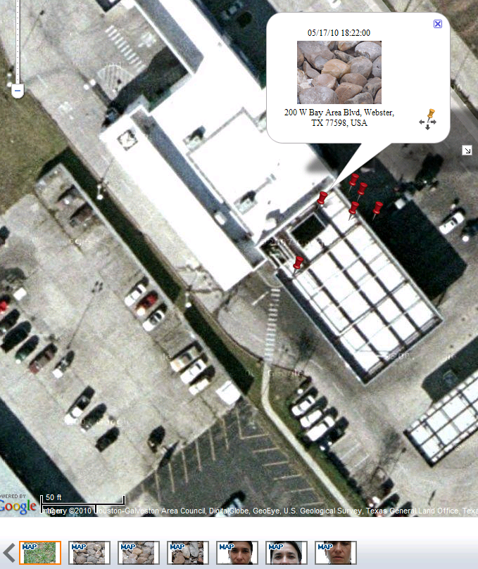
3. GPS actually fixed pretty quickly, about 2 min max (for the first out of the box fix, not bad!) when I was sitting outside waiting for car oil change, and it was not clear view of skies, I was on the side of the hole in concrete awning, sort of an atrium. Even without base maps, it displays pretty accurate location of the picture (through Intelli-Studio, it even shows address of Car Spa I was sitting at). Accuracy spread was also OK for not dedicated GPS, considering I was siting not in the crear sky view. The popped out picture of the stones actually shown exactly where I was sitting, other pins are close by (I did not move while taking all 7 pictures), but this spread to be expected even on hight end GPS.

Cons:
1.No hard copy user manual is included. Manual is on CD (and that is only thing which is on that CD, pretty wasteful, as all base maps on web, and manual as well, why include CD?). Although I like PDFs and generally prefer having a softcopy on computer for referral, sometimes it is nice to being able to play with camera outside and refer to book manual. I should go through additional loops to convert PDF to use on Kindle or Win Mobile Phone. Or netbook?:)
2. Basemap download and install is not easily available, see above. Although I found it and downloaded relatively painlessly, I am still working on getting basemaps on camera SD, this will be separate post. Also space limits - I will have to fill about 1 Gb with base maps...

Conclusions: I really like this camera and can envision having it with me at all the times. I am not a good photographer, but like to learn. Also I follow the motto "the best camera is the one you have with you". We got DSLR Pentax for Christmas, but it is too heavy and complicated to my taste, so my husband took it over, he likes to play with images and spends hours on editing. Now he shoots in RAW mostly, now there is always at least a week lag before he can post pictures. I don't like this. So this little Samsung will be My Camera.:)

Wednesday, May 12, 2010

Low-cost GPS logger

I had tested a small gadget called GPS logger from Columbus Visiontac.
Complete product name-description is:

Columbus V-900 Bluetooth GPS Data Logger (microSD , Voice Tag for POI, Driverless, Push to Log, 25 millions waypoints*, XP / Vista/ Linux / Mac OSX Compatible)

I tested it on some trips about a year ago. It is out of stock on most websites now, I don't know whats going on, but I have it and it is a cool little device both for fun and for field research. The cool feature is if you carry your digital camera and set up time in it to minute upon return to office you can link those pictures with Lat/Long and post on Google Earth for other to review. Or you can collect voice notes or waypoints and then load them to your PC and merge with other measurements. If you have it in your car all the time, it trucks your routs and date-stamp them so you can review notes and places you've been and merge that with soil maps, satellite imagery, etc. Indispensable for mobile Ag Consultant! I even tried to log EC data from Landmapper to merge with locations. It has worked a year ago, but now dis-organized as I am, I lost manual and software which came with it for PC communication. It still works and I have a whole bunch of data on it from recent trip to Winnie, TX - I was there mapping soil salinity on rice fields, but I cannot get it out!:( I will continue searching internet and my house, but may be someone can help with this??? Ok, that was pretty easy. Here is manufacturer website for downloads.Current versions are
Columbus V-900 User Manual V1.2 English Version updated 08-11-10 1.29M
Time Album V1.8 English Version
Updated: 10-03-31  1132K

 I will try to set up my new laptop with this and get those data out!
Setup instruction:
  1. Download and install Java (free, click here to download). It will ask you to verify your version of Java.
  2. Download and unzip the Time Album application (see link above).
  3. Launch the TimeAlbum application by double clicking on the unzip file above.

Tuesday, May 11, 2010

Solid Earth Geophysics Encyclopedia

Landmapper will be featured in 2nd edition of Solid Earth Geophysics Encyclopedia as the best small scale portable and accurate electrical resistivity/conductivity meter. Click here to read a draft of the article in 2nd edition of Encyclopedia.

1st edition Encyclopedia of Solid Earth Geophysics can be found here.
James, D.E. (Ed.)
Version: eReference (online access)
1990, 1344 p. eReference.
ISBN: 978-0-387-30752-7

Friday, March 26, 2010

APPLICATIONS OF SELF-POTENTIAL METHOD IN AGRICULTURE

full proceeding paper was presented at SAGEEP, April 11-15 2010, Keystone, CO.
Larisa Golovko, Landviser, LLC, Houston, TX
Anatoly I. Pozdnyakov, Moscow State University, Moscow, Russia
View/download slides    View/download full proceeding paper 
citing this paper:

Golovko, Larisa, and A.I. Pozdnyakov. “Applications of Self-potential Method in Agriculture.” 8 p. on CD–ROM. Keystone, CO: Environmental and Engineering Geophysical Society, 2010. http://www.landviser.net/webfm_send/168.

Abstract
Electrical geophysical methods are classified as methods measuring natural electrical potentials of the ground without introducing additional electrical field and methods utilizing artificial electrical or electromagnetic fields to measure soil electrical parameters. Method of self-potential (SP) measures the naturally existing electrical potentials in soils and “bio-potentials” in plant, which are important in agriculture. Despite growing popularity of electrical resistivity/conductivity methods in precision agriculture, method of self-potential is rarely used. The SP method is based on measuring the natural potential differences, which generally exist between any two points in the soil or plant. Electrical potential in Soil-Plant system is a combination of the natural electrical potential differences on the interfaces inside soil (between soil horizons or peds), on the interfaces inside growing plant (between different plant tissues), as well as between soil and plant. The largest electrical potential differences were observed inside soils between soil horizons drastically different in physical and chemical properties. In most soils topsoil has higher electrical potentials than subsoil. The highest potential difference between soil horizons reported for Spodosols (40-60 mV), decreasing to 20-40 mV in Alfisoils and to ~20 mV in Mollisols, and even lower in Aridisols.  Maps of electrical potentials in topsoil help to reveal the micro-environments for plant growth and correspond to plant biomes in natural ecosystems. Electrical resistivity (ER) or conductivity (EC) maps are generally similar to the maps of self-potentials, but using combination of those methods brings more information about infiltration and subsurface water fluxes and aid in search for clogged drainage pipes and reclamation planning. Recent advances in geophysical equipment, such as LandMapper ERM-02 also allow non-invasively measure natural electrical potentials between soils and plants, which are very small (µV magnitude), but nevertheless can be used to study plant water and nutrient stresses and manipulated to facilitate plant growth.
  
Introduction
Many kinds of electrical fields and potentials are often simultaneously observed in natural soil; thus, it is difficult to know what mechanism is responsible for their formation. Stationary electrical fields originated in deep geological formations can be observed in soils together with electrical fields of a various nature, arising directly in soil profiles (Semenov, 1980). The potentials originated in soil profiles were classified into diffusion-adsorption potentials, electrode potentials, and potentials of “varying in time fields" (Semenov, 1980). The “geological” potentials are limited to certain natural conditions, such as sharp change of oxidation-reduction conditions above an ore deposit or perched mineralized groundwater. The natural “soil” electrical potentials, on the contrary, can form under any soil condition.
 All the natural electrical fields can be classified by mechanisms and nature of their occurrence in two large groups: electrical fields of stationary processes, existing on the contacts of various media and non-stationary, transient, electrical fields, arising in saturated and unsaturated soils due to movement of soil solutions.  The most widespread electrical fields in soils are attributable to diffusion-adsorption potentials, in which sorption typically contributes more than diffusion. The natural electrical fields are measured together with electrode potentials, which can be considered as artificially created potentials on the contacts of electrodes with soil.
Natural electrical fields and their potentials were studied in some soils in Russia (Borovinskaya, 1970; Vadunina, 1979; Pozdnyakov et al., 1996). Vadunina (1979) indicated that potentials measured on the soil surface could be used to estimate different soil properties in the whole soil profile. The measurements of natural potentials on the surface of some Aridisols (including Natrargids) and Alfisols (Pozdnyakov et al., 1996) show that such estimation is possible only when the surface soil horizons are genetically related to the other horizons in the soil profile.
We consider soil electrical potentials as diffusion-adsorption potentials on the contacts of different soil structures, such as soil aggregates, horizons, and pedons in topographic sequences. This concept, based on Poisson’s and Maxwell’s laws of electromagnetism and Boltzmann’s distribution law of statistical thermodynamics, was used to explain relationships among various soil properties, mobile electrical charges, and electrical parameters. The theory considers soil cover as a huge "source" generating natural electrical fields and allows constructing models of electrical profiles in various soils.

History of self-potential method in geophysical prospecting

The SP method was used by Fox as early as 1830 on sulphide veins in a Cornish mine, but the systematic use of the SP and electrical resistivity methods in conventional geophysics dates from about 1920 (Parasnis, 1997). The SP method is based on measuring the natural potential differences, which generally exist between any two points on the ground. These potentials are associated with electrical currents in the soil. Large potentials are generally observed over sulphide and graphite ore bodies, graphitic shale, magnetite, galena, and other electronically highly conducting minerals (usually negative). However, SP anomalies are greatly affected by local geological and topographical conditions. These effects are considered in exploration geophysics as “noise”. The electrical potential anomalies over the highly conducting rock are usually overcome these environmental “noise”, thus, the natural electrical potentials existing in soils are usually not considered in conventional geophysics.

 Perspective of self-potential method in environmental, agricultural and engineering applications

In soil studies researchers are especially interested in the measurement of such “noise” electrical potentials created in soils due to soil-forming process and water/ion movements. The electrical potentials in soils, clays, marls, and other water-saturated and unsaturated sediments can be explained by such phenomena as ionic layers, electro-filtration, pH differences, and electro-osmosis. Soil-forming processes can create electrically variable horizons in soil profiles, thus electrical potential differences measured between soil horizons can be used to study soil forming processes and soil genesis.
Another possible environmental and engineering application of self-potential method is to study subsurface water movement. Measurements of electro-filtration potentials or streaming potentials have been used in Russia to detect water leakage spots on the submerged slopes of earth dams (Semenov, 1980). Method of self-potential in addition to EC mapping and vertical electrical sounding/ imaging (VES) can aid in archaeological and civil engineering projects (Pozdnyakova et al., 2001).

Wednesday, February 24, 2010

QUICK ESTIMATION OF SALINITY IN FIELD SOILS AND IRRIGATION WATER WITH LANDMAPPER® ERM-02

Soil salinity is routinely evaluated in the labs from electrical conductivity of liquid soil saturation extract (ECe). The resulted total salinity is reported either directly in conductivity units (dS/m) or converted to TDS (total dissolved solids) concentration in ppm (parts per million) using formula:
1 dS/m = 1 mS/cm = 1 mmho/cm = 640 ppm = 640 mg/L= 0.64 g/L=0.064%
But now EC of soil and waters can be measured directly in the field using highly accurate method of four-electrode probe and Landmapper ERM-02 measuring device. Best of all, probes can be build to sense different soil layers down to 30 ft! Probes are simple and inexpensive to make from common materials available at any hardware store.
For irrigation water and soil solutions: To measure ECw just put 4-electrode probe of Landmapper used for mapping into a ditch, canal, or other water source. Make sure that all 4-electrodes are in contact with water. Take a reading in EC (conductivity) mode. Display will read (example):  
K0*C= 150m  - which indicates milli Siemens (mS/m)
To convert to dS/m, divide display number by 100, i.e.
150 mS/m=1.5 dS/m.
Use the table below to quickly evaluate salinity of irrigation or surface water:

Salinity Class
Electrical Conductivity, ECw (dS/m=mS/cm=mmho/cm)
Total dissolved solids, TDS (ppm)
Nonsaline water
<0.7
<500
Saline water
0.7-42
500-30,000
Slightly saline
0.7-3
500-2000
Medium saline
3-6
2000-4000
Highly saline
6-14
4000-9000
Very highly saline
14-42
9000-30,000
Brine
>42
>30,0000
For field soils: Conventional analysis of soil salinity is cumbersome, since it requires collecting big soil samples, preparing soil paste and using vacuum extract apparatus to collect soil solution extract for measuring ECe. Farmer usually had to wait up to 10 days to get back results from the lab. Salinity is highly variable across the fields and with soil depth. Soil salinity is also highly dynamic and can drastically change during growing season depending on rain, irrigation and other management practices.
Landmapper ERM-02 can be used to check for dangerous salinity levels at different locations and soil layers directly in the field very quickly – one EC reading takes only 4 sec! Few samples can be collected from areas with extreme min-max levels of EC and salinity values can be double-checked at the laboratory using Landmapper ERM-02, laboratory 4-electrode box and simple and accurate procedure described in separate flyer. Scale for weighting soil and distilled water is the only additional equipment needed.
However, usually ECa measured directly in the field is enough to delineate spots of dangerous salinity within the field and design management/remediation plan.
ECa or apparent (bulk) electrical resistivity measured with LandMapper in the field can be related back to ECe by multiplying ECa*Ktexture. The Ktexture varies from 3 to 6 for typical loam and clay loam soils, and can be estimated from soil clay content and a graph at the left. However, those Ktexture for recalculation of ECa to ECe were derived for relatively dry California soils and if one is measuring ECa in wet situations like after heavy rain in saturated or flooded soil (also possible with Landmapper ERM-02!), Ktexture multiplication is not necessary. Recent measurements on rice paddies in TX have shown that at ECa=1.5 dS/m at 6” and 16” depth rice is thriving under full flood.
Remember, ECe or electrical conductivity of soil saturation extract is MAXIMUM soil salinity, and one should not be alarmed of high ECe values, especially if growing relatively salt-tolerant crops without excess water. ECa or bulk soil electrical conductivity is much more valuable as its shows amount of ACTIVE or MOBILE salts in soil profile under field soil moisture conditions.

Bulk soil electrical conductivity (ECa) is measured from soil surface to the depth in the big soil volume determined by the distance among four electrodes (ABMN) and therefore is more representative of field conditions than measurements in small soil sample or soil ECa insertion probe. The depth and volume of measurement may be varied by changing the spacing between electrodes. When the distance between the outside pair of electrodes (the current electrodes, AB) is small, the flow of electricity is shallower. The effective depth of measurement is about one-third of the distance between AB electrodes. The calculation of ECa from field measurements done with different size probes will be done automatically by LandMapper ERM-02 if geometrical coefficient Kg is set in device for specific probe. Kg can be calculated from distances among ABMN electrodes using formula below (input distances in meters):
 Four-electrode probes supplied by us will have Kg printed on the probe and saved in LandMapper ERM-02 memory. Device can store nine Kg (K1-K9) coefficients to facilitate quick changes in the field for up to 10 probes for different depths. Default K0=1 and cannot be changed. K0 is used with a probe to the depth ~6” where AM=MN=NB=a=16 cm or for resistance/conductance measurements.
Reference: Rhoades, J.D., F. Chanduvi, S. Lesch. 1999. Soil salinity assessment – Methods and interpretation of electrical conductivity measurements. FAO irrigation and drainage paper #57. FAO UNESCO Rome. ISBN 92-5-104281-0

Thursday, January 28, 2010

Setting up RES2DINV/RES3DINV (DEMO ver.) for the first time

Download DEMO version of RES2DINV from http://www.landviser.net/webfm
Visit hyperlinked pages to download DEMO versions of RES2DINV and RES3DINV and supplemental publications.
Note, that you can use RES2DINV without RES3DINV, but not other way around - RES2DINV have to be installed first. This demo software has decreased functionality, but it might be enough for your research and the DEMO versions never expire.
However, if you decide to purchase software, please request a formal quote from us ASAP before contacting GEOTOMO directly, as we will meet or beat price of other dealers, but we cannot guarantee it unless you secure order from us first.
Now, installing the software…
Click setup.exe and follow directions. When you run through set up series of questions, click OK to the question about dongle installation.
Setup will quit.

Then run the program from Start\Programs\RES2DINV or from folder where it has been installed.
Without a dongle you will see SemiDemo version. Click OK.


Big white screen will be there with menus on the top. If you see white screen only, my guess it is screen resolution on your PC system that makes it blown out of proportion. I did installed mine on VISTA Ultimate 64-bit using same file without any problem before, but today I happen to have Win XP 32-bit computer without RES2DINV, so I run setup.exe on it step by step. Works fine.

Go File/Run Jacobwin if you using a program for the first time. It will calculate partial derivatives for most popular arrays. You will not need to run it again ever on the same computer.


When you decided to purchase and receive your USB dongle in the mail, follow directions to install the dongle published in manual book. You will not need to un-install DEMO versions, the software will pick up dongle if it attached otherwise it will continue to run in semi-demo mode.

If you run into any problems with installation, please, do not hesitate to contact Landviser or post a comment in this blog.
info@landviser.com
Phone: 888-306-LAND (5263) or 1-609-412-0555 (International)

Wednesday, January 27, 2010

LandMapper® ERM-02 - versatile and affordable

Don’t break your back collecting soil samples. Reduce amount of samples sent for laboratory analysis and save money. And still make detail soil map of your fields, which will be more accurate than conventional soil surveys. Impossible? Not at all with LandMapper ERM-02.

This device measures three important electrical properties of soil: electrical resistivity (ER), conductivity (EC), and potential (EP). Utilizing the most accurate four-electrode principle LandMapper measures ER or EC and helps delineate areas with contrasting soil properties within the fields quickly, non-destructively and cost-efficiently.
In a typical setting, a four-electrode probe is placed on the soil surface and an electrical resistivity or conductivity value is read from the digital display. Using the device prior to soil sampling you can significantly reduce the amount of samples required and precisely design a sampling plan based on the site spatial variability.
Bulk soil EC was correlated with salinity, texture, stone content, total available nutrients, water holding capacity, and filtration rates. Guided by detailed soil EC map obtained with LandMapper, only minimal amount of soil samples is needed to invert EC map into correlated soil properties. Also, LandMapper can be used to measure EC in soil pastes, suspensions and solutions and quickly estimate total dissolved salts (TDS) in solid and liquid samples.
LandMapper ERM-02 was successfully used for non-destructive mapping and monitoring of agricultural fields as well as construction, remediation and archaeological sites.
The device measures ER or EC in soil from 1 inch down to 30 feet, depth is set by changing four-electrode probes of different sizes. Probes can be easily assembled from inexpensive materials available at any hardware store.

Repeat the measurements using series of probes with increasing distances among electrodes and collect detail information about soil horizons, hardpan and groundwater depth. Additional processing of such ER data allows to plot 1D, 2D and even 3D images of subsurface (RES2DINV and RES3DINV software developed by Geotomo is available through Landviser as well).
LandMapper is resistivity meter and datalogger (stores 999 readings), but not a multiplexer, but some researchers from USDA constructed manual multeplexer interface for LandMapper. ERM-02 model has option of directing measurement by PC. Software is being developed by us for multiplexing and monitoring studies with LandMapper.

LandMapper ERM-02 is the most versatile device in LandMapper series and allows you not only measure ER and EC using artificially applied electrical current and four-electrode probes, but also study natural electrical fields in soils and plants with non-polarizing electrodes. Electrical balance between soil and plants is important for plant health; electrical potential gradient governs water and nutrient uptake by plants.

Key Features
  • Compact and portable design (weights only 250 g without the probe)
  • Fast (one measurement takes 4 sec)
  • Accurate (Automatically adjusts electrical resistivity (ER)/conductivity (EC)/potential (EP) ranges to provide best measurement accuracy >99%)
ER= 0.01-1,000,000 Ω m
EC= 0.000 001 – 10 S/m
EP = -1 to +1 V (D=0.01 mV)
  • Safe and reliable (uses a standard 9 V battery)
  • PC connected for data transfer (stores 999 data values in non-volatile memory)
  • Modular and interchangeable (detachable measuring unit accepts mapping 4-electrode probes, sounding cables, laboratory cells, micro-probes, and non-polarizing electrodes)
  • Versatile (the same unit can be used for field mapping, measurements in soil, plant and food samples as well as on live plants and animals)
  • Affordable (inquire about our very competitive prices and rental rates (US only)  as well as available educational and multiple unit discounts) 
Download this info as a 3-fold brochure
To discuss your research needs and applications contact us at
info@landviser.com
Phone: 888-306-LAND (5263)  or 1-609-412-0555 (International)
Fax: 815-301-8955

Monday, January 18, 2010

Inventory list of Landviser, LLC 2010


I have just updated our inventory/pricing for devices and Res2DINV geophysical software, since GeoTomo increased price for software and also released RES3DINV for 64-bit processors (PC only). Note that GeoTomo Software is based in Malaysia and does not accepts credit cards. They sell their world-renowed geophysical interpretation software directly (wire transfers) and through world network of dealers. Landviser, as a manufacturer of geophysical equipment is an autorized dealer for this software. All dealers are required to quote the same price, however not all accept credit cards and offer free shipping and software support, as Landviser does. Please, consider this before requiring comparison quotes simultaneously from several dealers. If we are not the first dealer served you a quote, software developer might restrict the sale through us and you will have to use wire transfer and purchase directly from GeoTomo.
As I am learning Google Docs and Blogging, I published this document on both places.

Current Inventory and Price list (2012)

INVENTORY LISTING AND QUOTE (valid until March 31, 2010)

Electrical Geophysical Devices

              produced by ASTRO (Russia) exclusively for Landviser, LLC (USA)


Product

Description 

Price

Availability

Landmapper ERM-01

Hand-held geophysical device measuring electrical resistivity by the method of four-electrode probe. Includes User Manual, 4 test leads (electrodes), CD with software and information, and serial cable for data download

$979

Discontinued. Sold out.
Inquire about refurbished units

Landmapper ERM-02

Hand-help geophysical device measuring electrical resistivity, conductivity and potential. Includes user manual, 4 test leads (electrodes), CD with software and information, and serial cable for data download to PC or directing electrical measurements from PC

$2397
or rent for
$197 per week (USA only)

NEW in ERM-02 model:
* Accurate saveable potential measurements
* Direct your ER/EC/EP measurements from PC!

In stock

Accessories for Electrical Geophysical Devices

               made or modified by Landviser, LLC (USA)


Product

Description 

Price

Availability

4 measuring test leads

Two red and two black measuring electrodes complete with 1 m cable and banana plugs.

$16(four)
$8 (two)

In stock

4 gold-plated disk electrodes set

Non-corrosive electrodes to measure ER/EC of highly corrosive or hard material, living organisms (use conductive TENS gel).

$60 (four)
$15 (one)

In stock

Laboratory
4-electrode cell

Plastic cell with alligator-clip test leads and banana plug connections. Used for measuring ER/EC in solutions, slurries, suspensions, soil samples

$79

In stock

Soil probe kit

Kit for do-it-yourself four-electrode probe (includes 4 sharpened stainless steel electrodes, 8 nuts, 4 ring terminals, 4 banana plugs)

$19

In stock

Soil pit probe

4-electrode probe to measure electrical resistivity/conductivity in soil pits, pots and other samples of semisolid media.

$26

In stock

Small soil mapping probe

4-electrode probe to measure electrical resistivity/conductivity in topsoil (<=30 cm). Typical sizes: a=10, 15, 20, 25, 30 cm.

$36

In stock

Medium soil mapping probe

T-shaped probe for fast mapping topsoil down to 0.5 m, Wenner or any customer specified configuration with a<=0.5 m.

$47

In stock
Most popular probe

Big soil mapping/VES cable set

4-electrode cable set with pre-set distances to measure soil electrical resistivity/conductivity down to 5 m.

$89

In stock

Consulting Services


Product

Description 

Price

Availability

Geophysical data interpretation

ER and IP data analysis and interpretation using RES2DINV/RES3DINV software. Comprehensive reports including GIS electronic maps and background geology/soil analysis.

$70 per hour or project-based

Billable hours determined before committing to the project

Statistical and geostatistical data analysis

Comprehensive analysis of research data. Help with experiment design and report preparation.

$90 per hour or project-based

Billable hours determined before committing to the project

Soil and GIS consulting

Our knowledgeable staff will gather and analyze GIS data for your project including environmental data, public census information and proprietary enterprise data. Our services range from global and regional GIS market analysis to urban & agronomical soil mapping

$60 per hour or project-based

Billable hours determined before committing to the project

Geoelectrical Imaging Software

               developed by GeoTomo Software (Malaysia), distributed by Landviser, LLC (USA)

The demo version of the software can be downloaded from http://www.landviser.net/webfmThe demo version has no time restrictions and offer almost complete functionality, but the interpretation results and models cannot be saved without authorized dongle (USB). The support is provided by developer and/or Landviser via phone or email indefinitely.


Product

Price for Commercial/Non-Academic Institutions 

Price for Academic Institutions*

Availability

RES2DINV

$2700

$2430

In stock. Software manual, CD and a USB dongles to unlock demo version are shipped from USA.

RES2DINV plus RES3DINV

$3700

$3330

RES3DINV -64bit plus RES2DINV/RES3DINV -32bit

$5000

$4500


The price is one time payment and there are no annual support fees. Upgrades are always free for the registered customers.

Academic institutions get significant discount.

Upgrades


Instantly via email

from RES2DINV to RES2DINV/RES3DINV

$1200

$1200


from RES3DINV-32bit to RES2DINV/RES3DINV -64bit

$1500

$1500


from RES2DINV to RES2DINV/RES3DINV -64bit

$2500

$2500


For the second copy of the software purchased by the same customer, there is a 20% discount for academic institutions and a 10% discount for other customers from the full price.

RES2DINV

$2430

$2160

For purchases with the second copy discount, technical support will only be provided to the same customer at a single office.

RES2DINV plus RES3DINV -32bit

$3330
or rent for $397 per month (USA only)

$2960

RES2DINV plus RES3DINV -64bit

$4500

$4000
*Academic institutions are defined as institutions with registered undergraduate or postgraduate students that award recognized academic degrees (BSc, MSc, PhD). This does not include government institutions such as the geological surveys in many countries.
Payment Terms:

All prices are in US Dollars. Orders are fulfilled after the payment is received in full.
We accept credit cards (VISA or MC) or wire transfers to our bank account in USA.
Customers from USA may also pay by electronic check or Purchase Order. Customers from Russia are served by regional office in Moscow.

Landviser, LLC (USA)
828 Davis Rd., League City, TX 77573
Toll-free: 888-306-LAND (5263) Phone: 609-412-0555
info@landviser.com
Main: http://www.landviser.com/  Support/eLibrary/Blog: http://www.landviser.net

-----------------------------------------------------------------------------